Getting There

The Kapoho Cemetery is on the road that leads to the Cape Kumukahi Lighthouse in lower Puna district. If you are planning to visit the cemetery or lighthouse you might consider taking the Honolulu Landing to Kumukahi Lighthouse Scenic Drive, which includes both near the end of the drive.
To drive straight to the cemetery take Highway 130 towards the town of Pāhoa. Pass the first intersection that takes you into Pāhoa as well as the next left. At the next intersection with a traffic light make a left at the intersection onto Pāhoa-Kapoho Road (this is also Highway 132). Follow this road past the Lava Tree State Park. Care should be taken on this road as it's quit narrow in places and has a lot of curves. This is a beautiful section of road so enjoy the trees and plants.
Continue on Highway 132 to the end. At the end you can turn left or right onto a paved road, or continue straight onto a dirt road. To get to the cemetery and lighthouse, continue straight onto the dirt road. In about 1/2 mile there will be a dirt road to the left leading to the Pu'u Kuki'i Cinder Cone. Turn left and continue to the gate. Park and walk around the gate and follow the road a few hundred yards to the cemetery.
Click here to view a map
General Information
The trail to the cemetery is less than half a mile round trip. It is a dirt road, which leads directly to the cemetery and is very easy to follow. There are no bathrooms or other facilities at the cemetery though there is undrinkable catchment water to use for watering flowers for the gravesites. Other than your camera you do not need to bring supplies on this walk.
Things To Be Careful Of

The cemetery is situated on the edge of a cinder cone. The lip of the cone is directly behind the cemetery. Portions of the cemetery and graves are overrun by lava. If you have children with you keep an eye on them so they do not trip on the rough lava nor fall into the cinder cone (which has a 20 to 30 foot drop in places).
The Kapoho Cemetery is still a working cemetery. As with all cemeteries and gravesites treat them with respect.
What You Will See
After parking your car at the gate simply walk around the gate and follow the trail up into the Pu'u Kuki'i cinder cone. As you go you may see some interesting plants and flowers such as the Shrimp Plant.
As you enter the tree line you may notice an overgrown road branching to the left - to another locked gate. That road leads further up the cinder cone to an ancient Kuki'i Heiau. Pass the overgrown side road and continue on the road you are on for a little further until you see the cemetery building.
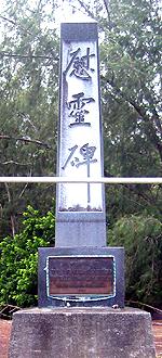
As you approach the cemetery you will see a small building that is used for gatherings and to avoid the rain. Near the building is a monument that was erected in 1962 in honor of the graves that were covered in the 1960 eruption.
The cemetery is a Japanese and Hawaiian cemetery. Looking towards the ocean, most of the graves to the left are Japanese and most of the graves to the far right are Hawaiian. The cemetery used to stretch towards the ocean under the area now covered by lava.
If you approach the lava you will see many graves that are either partially buried under the edge of the lava, or completely buried and marked by an urn or other marker sitting on the a'a lava itself.
In 1959 the eruptions at Kilauea stopped for a period causing pressure to build in the Kapoho fault that runs from Kilauea east into lower Puna. By early 1960 earthquake swarms were continuous and the town of Kapoho was evacuated of the 300 residents who lived there. On January 13, 1960, the eruption occurred near the Kapoho fissure causing lava to fountain over 320 feet into the air.
For several days, workers toiled with bulldozers to keep the lava from threatening various historical sites as well as farmland and houses. But on January 18 the lava started to directly threaten the town of Kapoho.
Barrier after man made barrier was created all the way up to Pu'u Kuki'i - with each barrier being easily crushed by the onslaught of a'a lava. On January 30 the Kapoho School was lost but the final barrier remained intact until February 5. By this time the a'a had reached the top of the final barrier, overflowed it and completely surrounded Pu'u Kuki'i and partially covering the Kapoho cemetery.
The eruption finally stopped on February 19. The entire town of Kapoho was lost. Over 7 square miles of land had been covered by a'a lava and over 1.2 square miles of new land extended into the ocean.