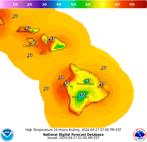
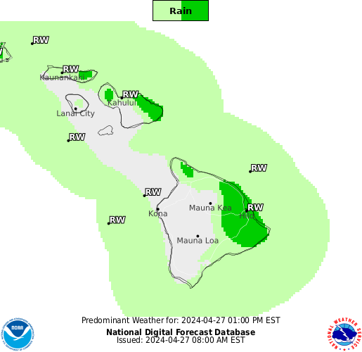
| Hilo Hawai'i - Current Conditions & 6-Day Forecast |
Currently
Overcast
Temp 72°F
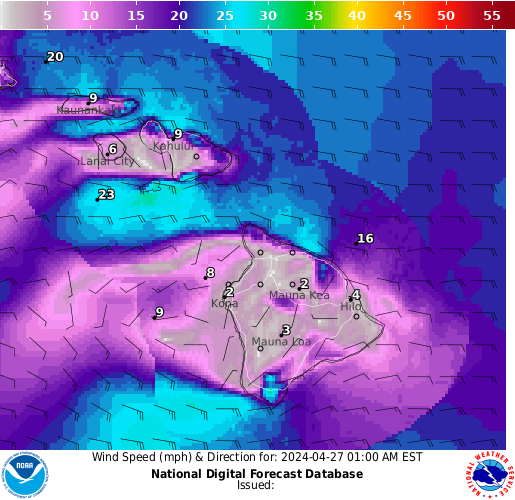
Wind W 3

Sampled at
01:53
|
Sky Conditions |
Visibility |
Dewpoint |
Pressure |
SeaLevel
Pressure |
| Overcast @ 4700 ft. |
10.00 mi. |
65°F |
NA in. |
NA mb. |
Low
Temperature |
High
Temperature |
Rain in
Last Hour |
Rain in
Last 3 Hours |
Rain in
Last 6 Hours |
| 72 |
77 |
30.09 in. |
1018.7 in. |
- |
Friday
July 18 | Saturday
July 19 | Sunday
July 20 | Monday
July 21 | Tuesday
July 22 | Wednesday
July 23 |

Low: NA
High: 84°F
Rain: 0%/40% |
Low: 71°F
High: 85°F
Rain: 50%/50% |
Low: 71°F
High: 85°F
Rain: 60%/50% |
Low: 71°F
High: 85°F
Rain: 40%/40% |
Low: 71°F
High: 85°F
Rain: 40%/30% |
Low: 71°F
High: 85°F
Rain: 50%/30% |
| Kona Hawai'i - Current Conditions & 6-Day Forecast |
Currently
Overcast
Temp 77°F
Wind NE 5
Sampled at
00:53
|
Sky Conditions |
Visibility |
Dewpoint |
Pressure |
SeaLevel
Pressure |
Scattered @ 2400 ft.
Overcast @ 3400 ft. |
10.00 mi. |
66°F |
NA in. |
79 mb. |
Low
Temperature |
High
Temperature |
Rain in
Last Hour |
Rain in
Last 3 Hours |
Rain in
Last 6 Hours |
| - |
- |
30.04 in. |
1017.2 in. |
- |
Friday
July 18 | Saturday
July 19 | Sunday
July 20 | Monday
July 21 | Tuesday
July 22 | Wednesday
July 23 |
Low: NA
High: 87°F
Rain: 0%/10% |
Low: 75°F
High: 87°F
Rain: 20%/10% |
Low: 75°F
High: 87°F
Rain: 10%/10% |
Low: 76°F
High: 87°F
Rain: 10%/10% |
Low: 75°F
High: 87°F
Rain: 10%/10% |
Low: 75°F
High: 87°F
Rain: 10%/10% |
| Hawai'i Volcanoes National Park 6-Day Forecast |
Friday
July 18 | Saturday
July 19 | Sunday
July 20 | Monday
July 21 | Tuesday
July 22 | Wednesday
July 23 |
Low: NA
High: 70°F
Rain: 0%/30% |
Low: 58°F
High: 69°F
Rain: 30%/60% |
Low: 59°F
High: 69°F
Rain: 50%/50% |
Low: 59°F
High: 69°F
Rain: 40%/40% |
Low: 59°F
High: 70°F
Rain: 30%/20% |
Low: 58°F
High: 70°F
Rain: 30%/30% |
| Saddle Road (Bradshaw) - Current Conditions |
Currently
Fair
Temp 56°F
Wind E 6
Sampled at
01:55
|
Sky Conditions |
Visibility |
Dewpoint |
Pressure |
SeaLevel
Pressure |
| Clear |
10.00 mi. |
37°F |
NA in. |
NA mb. |
Low
Temperature |
High
Temperature |
Rain in
Last Hour |
Rain in
Last 3 Hours |
Rain in
Last 6 Hours |
| 53 |
67 |
30.40 in. |
1016.5 in. |
- |
| Mauna Kea Summit 6-Day Forecast |
Friday
July 18 | Saturday
July 19 | Sunday
July 20 | Monday
July 21 | Tuesday
July 22 | Wednesday
July 23 |
Low: NA
High: 47°F
Rain: 0%/40% |
Low: 36°F
High: 43°F
Rain: 20%/20% |
Low: 38°F
High: 46°F
Rain: 20%/20% |
Low: 38°F
High: 46°F
Rain: 30%/10% |
Low: 40°F
High: 47°F
Rain: 10%/10% |
Low: 40°F
High: 49°F
Rain: 10%/10% |